Houston, We Have a Problem
The importance of satellite constellations for collecting location and archival data from marine organisms and what happens when systems change
Understanding the movement patterns of migratory marine organisms can be difficult as these species spend a large amount of time out of reach of direct observation. Therefore, satellite-based tracking systems, such as Argos, allow researchers to monitor the spatial and vertical distribution of marine organisms over extensive inaccessible habitats by communicating with animal borne sensors. But what is the Argos system and how does it connect to animal-borne platforms?
Argos transmitters are deployed on remote platforms (i.e., satellite tags and oceanographic buoys) that transmit data to any Argos equipped satellite in range, that transfers the data via operations centres to end users. Location data for each platform is calculated using the Doppler effect where the strength of the transmission frequency obtained by the satellite is used to pinpoint a platform’s location on earth (See Figure 1 for greater detail). In short, the more messages the satellite receives from the remote platform the greater the accuracy of the calculated location.
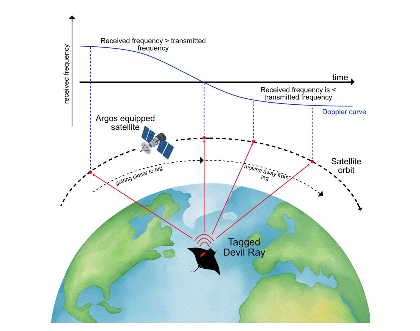
Figure 1. Graphic depicting how Argos calculates location data from transmissions received from remote platforms such as animal-borne satellite tags. As a satellite approaches a transmitter (i.e., a tagged sicklefin devil ray) the tag’s transmission frequency increases. However, once the satellite passes over the transmitter and begins to move away from it, the frequency of transmission decreases. The pattern of these frequency shifts is analysed at Argos operations centres to calculate location data wherein the degree of accuracy is dictated by the number of transmissions received. Locations are ranked as either Class 3, 2, 1, 0, A, B, and Z; wherein a class 3 position is the most accurate (within 250m), class B is the least accurate (no defined error radius), and class Z locations are considered invalid (Argos User Manual, 2016). The mobula vector used in this graphic was created © Eloisa Pinheiro Giareta and was edited by Sophie Prendergast to depict a tag. The original vector can be found here. The satellite vector © Getty Images, and the globe graphic © Maya Sagita
At the start of 2025, eight Argos equipped satellites (predominately large, over 1000kg) collected data from thousands of remote platforms globally. However, in the second half of 2025, three NOAA satellites (NOAA-18, NOAA-19, and NOAA-15) were decommissioned, due to unexpected technical failures or the end of their operational lifespan (Talpett 2025b). For decades NOAA has been an integral partner of the Argos system, however as the USA shifts its focus from earth observation to national deffense, the potential for continued collaboration remains uncertain.
Since 2019, CLS, the company that commercialised Argos, has been working with Kinéis to expand its constellation and improve global Argos coverage. The Kinéis constellation consists of 25 low-orbiting nanosatellites (satellites weighing less than 10kg), 20 of which are equipped with the Argos system. However, integration of data from the Argos legacy system with the Kinéis constellation was not completed until October 2025. Thus, during the transition period (July – September) there was a reduction in Argos coverage wherein end users received fewer locations from remote platforms (Talpett 2025b). Although CLS and Wildlife Computers informed their users about the loss of NOAA satellites and the potential for limited data products during the transition period, we were unable to fully anticipate the impact this would have on our work.
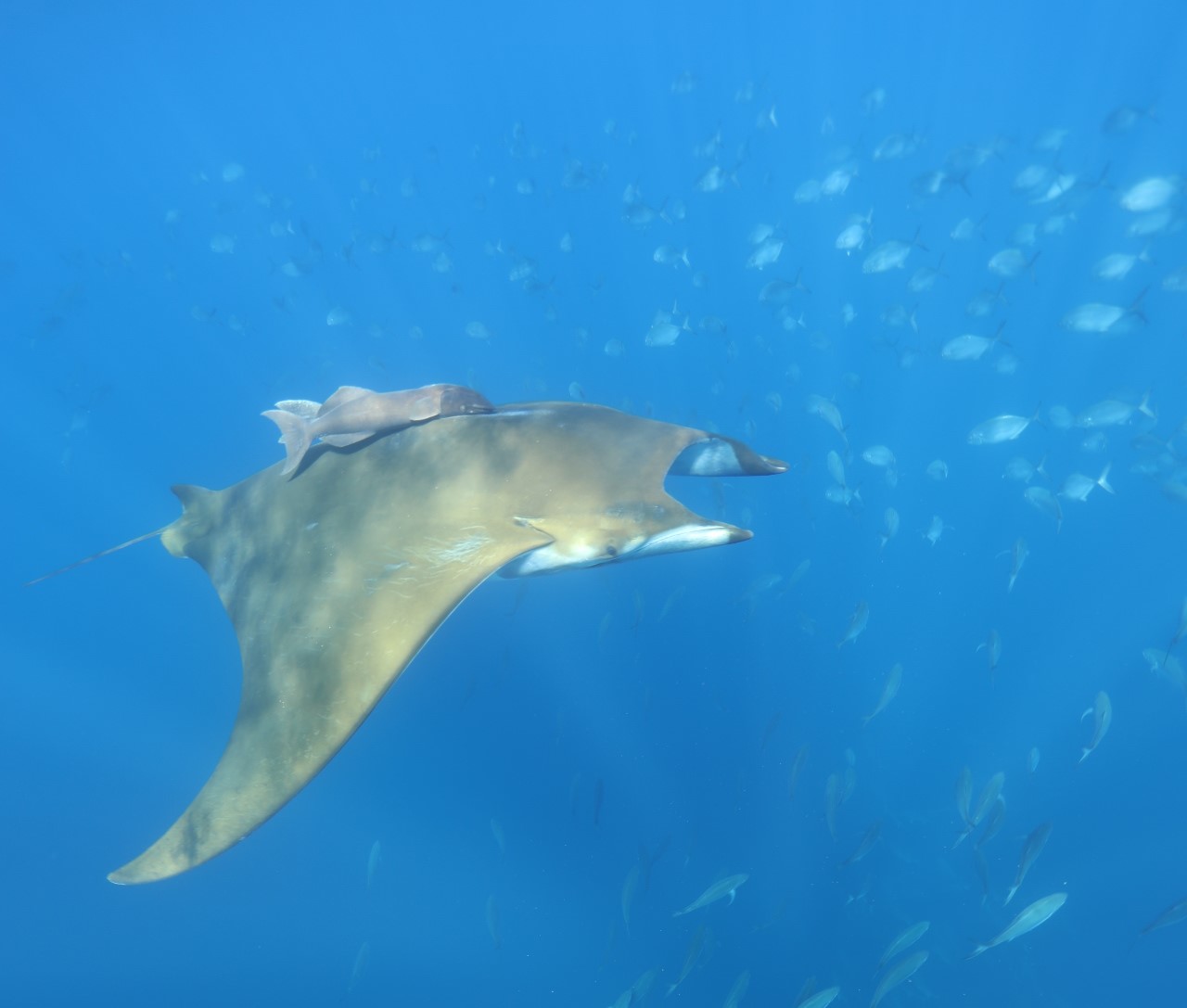
A sicklefin devil ray, Mobula tarapacana, at Ambrosio Seamount off the coast of Santa Maria Island in the Azores Archipelago. Photo © Dr. Jorge Fontes
As a result of the decommissioned satellites, there have been more gaps in global Argos coverage resulting in fewer transmissions from animal-borne tracking platforms. In areas such as the Azores Archipelago, which already experiences some large gaps in satellite coverage, the loss of the NOAA satellites made animal tracking more difficult. Our Remora Tag includes a SPOT-365 sensor from Wildlife Computers which transmits messages to Argos-equipped satellites when its antenna breaches the ocean’s surface. If there are no Argos-equipped satellites in range when the tag is at the surface, then no data is transmitted.
When the Remora Tag was deployed in July of 2025, we expected to receive fewer locations, but not so few that recovery would be impossible. Therefore, the tag was deployed for 72h on a sicklefin devil ray at Princess Alice with the goal of collecting acceleration and muscle temperature data from a dive below the thermocline (where water temperatures are markedly cooler than the surface) to better understand the species thermal capacity within changing environments. However, the release date came and went with no locations from the tag. The team searched for the Remora Tag at sea for two weeks before the efforts were called off. It wasn’t until September 3rd that the tag finally sent a single successful transmission 248 kilometers from Faial Island, too far to recover with our resources.
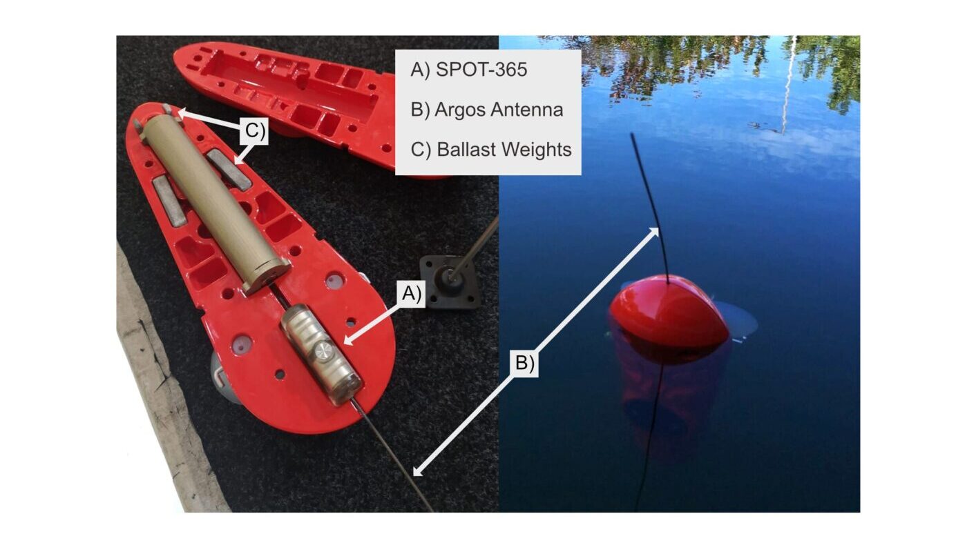
(Right) Image of the Remora Tag housing and sensors and (left) image of the Remora Tag floating in water at CEiiA’s test centre. Images © CEiiA
We contacted Wildlife Computers and CLS to ask for assistance regarding the lack of transmissions, and they granted us temporary access to data from the Kinéis constellation to check for additional transmissions. The Kinéis constellation had received 33 transmissions from the Remora Tag during the period from July 9th – September 3rd, compared to the single successful transmission received by the remaining legacy Argos satellites during the same time. However, this was a lot fewer transmissions than is expected from a tag floating at the surface for 2 months. While re-evaluating the deployment, we realised that the tag had been deployed without ballast weights. These small weights placed at the front of the tag help it stay upright in the water with the antenna positioned high enough above the surface to transmit clearly. Without these weights, it is likely that the Remora Tag is not floating properly which greatly reduces its’ ability to connect with passing satellites. Despite the setback, our team responded swiftly by analysing the issues and applying lessons learned to develop the Remora Tag 2.0. After thorough testing, we are now prepared to deploy the new tag in 2026 to complete our data collection for the project.
So, what happens now? With the rise of nanosatellites, it is likely that satellite coverage for a wide range of applications from environmental monitoring to animal tracking will continue to improve, especially in Portugal and its surrounding waters. In fact, we recently worked with MIT Portugal, Thales Edisoft, SpinWorks, CEiiA, along with multiple other Portuguese research institutions and Universities to develop and launch Portugal’s first ever nanosatellite, AEROS MH-1, in March of 2024 to improve Portugal’s ocean monitoring capabilities. You can read more about this project here and keep an eye out for our paper in the next issue of the Journal of Spacecraft and Rockets. We look forward to next field season to see how much the Kinéis constellation improves Argos coverage in our area. In the meantime, we are focused on analysing the incredible data we already have and look forward to sharing our results with you!
**References:
Argos User’s Manual. (2016). Worldwide tracking and environmental monitoring by satellite. June 15, 2016. https://www.argos-system.org/wp-content/uploads/2023/01/CLS-Argos-System-User-Manual.pdf
Taplett, N. (2025a) Important Update: Satellite Service Changes and the Future of Your Data – Wildlife Computers Inc. July 7, 2025. https://wildlifecomputers.com/blog/important-update-satellite-service-changes-and-the-future-of-your-data/.
Taplett, N. (2025b) Argos Satellite Constellation Update – Wildlife Computers Inc. September 24,