
Seychelles shines for sharks as IUCN releases eAtlas of Western Indian Ocean ISRAs
The nutrient-rich waters of the Somali Current, where strong upwelling brings life to light at the surface, are the breeding ground of blue sharks. Bull sharks move along an ocean corridor between Seychelles and Madagascar, and the Aldabra Atoll hosts feeding manta rays, breeding sharptooth lemon sharks and aggregations of scalloped hammerhead sharks. Along the Mahé plateau, an archipelago of 39 islands peppers the ocean to form the coral reefs and sea-grass beds, mudflats and mangroves of Seychelles’ Inner Islands, where threatened grey reef sharks and breeding scalloped hammerhead sharks are found.
The Important Shark and Ray Areas (ISRAs) eAtlas for the Western Indian Ocean, developed by the IUCN’s Shark Specialist Group, details 125 places that are critical to the long-term survival of sharks. These are the same places that are essential to the sustainability of livelihoods in an ocean region that supports about 220 million people. In 2019, the Western Indian Ocean Marine Science Association calculated that more than 60 million people live within 100 kilometres (62 miles) of the shoreline in the Western Indian Ocean and that the ocean brings in at least US$20.8-billion annually to people throughout its waters and the nations that govern them. It is vital to keep ocean ecosystems here healthy, but this cannot be achieved without sharks. And somewhere in the heart of the Western Indian Ocean, Seychelles stands out for its rich ocean heritage and commitment to conservation. With more than 30% of its ocean pledged to protection, Seychelles can make an outsized sustainability impact in these waters.
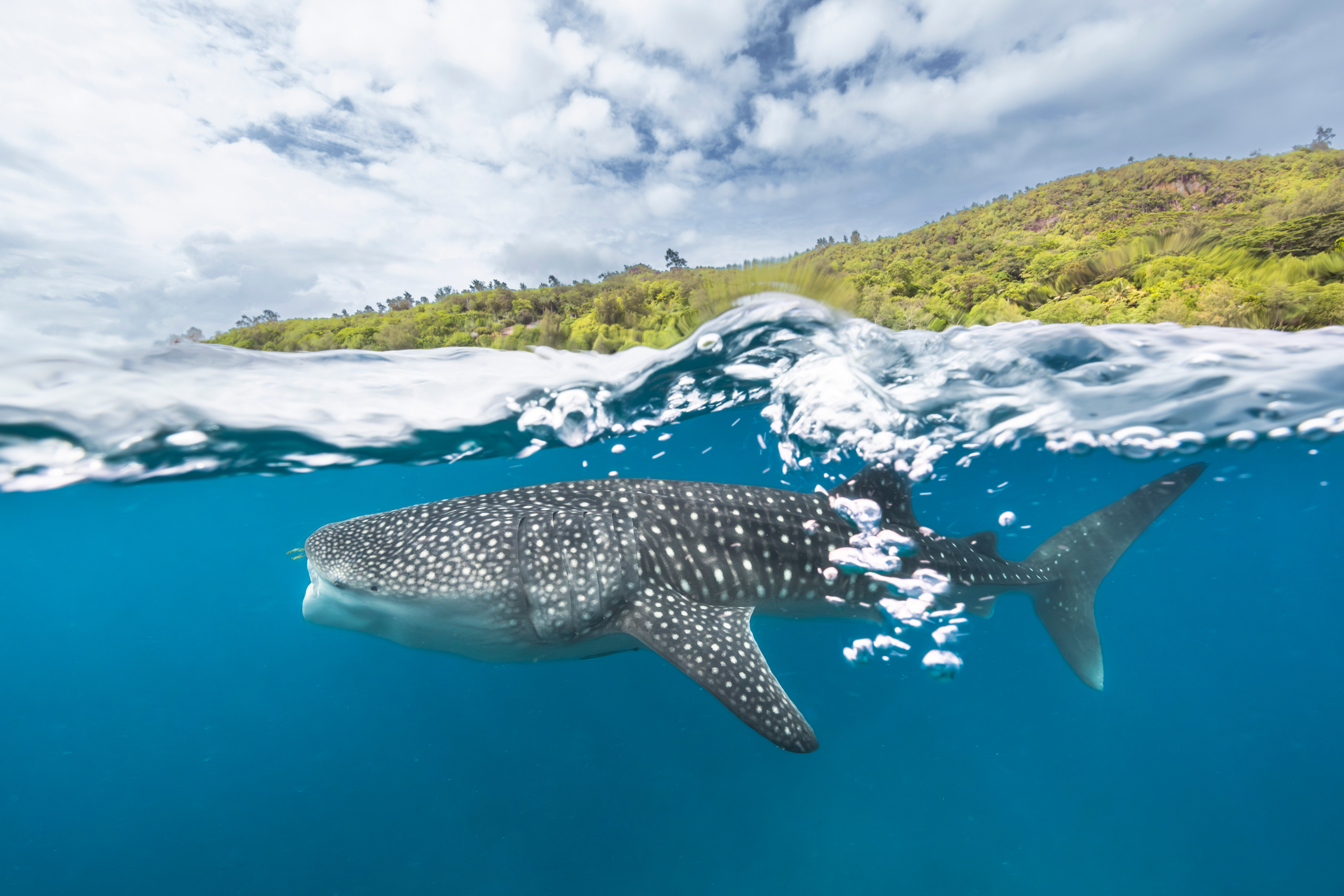
Understanding where sharks feed, breed and grow can help us to protect them at some of their most important and vulnerable life stages. Whale sharks have been recorded at critical feeding sites in the Southern Inhambane (Mozambique), Nosy Be (Madagascar), Southern Mozambique and Pomene (Mozambique) ISRAs in the Western Indian Ocean. Photo © Simon Hilbourne
‘One of the most valuable things about ISRAs is that they are entirely biocentric – based on ecological, not political, economic or sociological information – and rely on the data collected by so many scientists in the field,’ says Dr Robert Bullock, the director of research at the Save Our Seas Foundation D’Arros Research Centre (SOSF-DRC). ‘Many experts from countries across the region provided input for the ISRAs drafts, and these were compiled at a dedicated workshop with the ISRAs team. The drafts are then independently reviewed and new ISRAs are defined.’
The ISRAs process collates scientific data collaboratively to identify essential shark habitats. Where are the places most critical for the long-term survival of sharks? Where do they feed, breed and grow? The final important areas are added to an interactive global map (the eAtlas). ‘Having the ISRAs freely available on a website, with downloadable fact sheets and information layers, is without a doubt helpful,’ says Sheena Talma, a Seychellois marine scientist and the owner of Talma Consultancy. Sheena coordinates the SOSF-DRC D’Arros Experience, introducing young Seychellois to the splendour of their ocean inheritance and the critical importance of sharks in the Indian Ocean ecosystem. ‘Finding useful data is sometimes the hardest part of showing how important our exclusive economic zone is to sharks, but so is demonstrating how we need sharks for a healthy ecosystem.’
One of the key contributors to this body of knowledge is John Nevill. The Seychelles Inner Islands ISRA was developed based on his artisanal elasmobranch (sharks and rays) catch monitoring data for the period 2012–2020. These included some 25,000 individual records for sharks (covering 27 species) and about 2,000 for rays (covering 10 species). It’s a staggering dataset and forms a solid basis for evidence-based decision-making in the region. Data such as these, and the process that Robert outlines, give us insight into why the rigour and intensity of the ISRAs process is important for collating information that will ultimately be available to national governments, policy-makers and marine management.
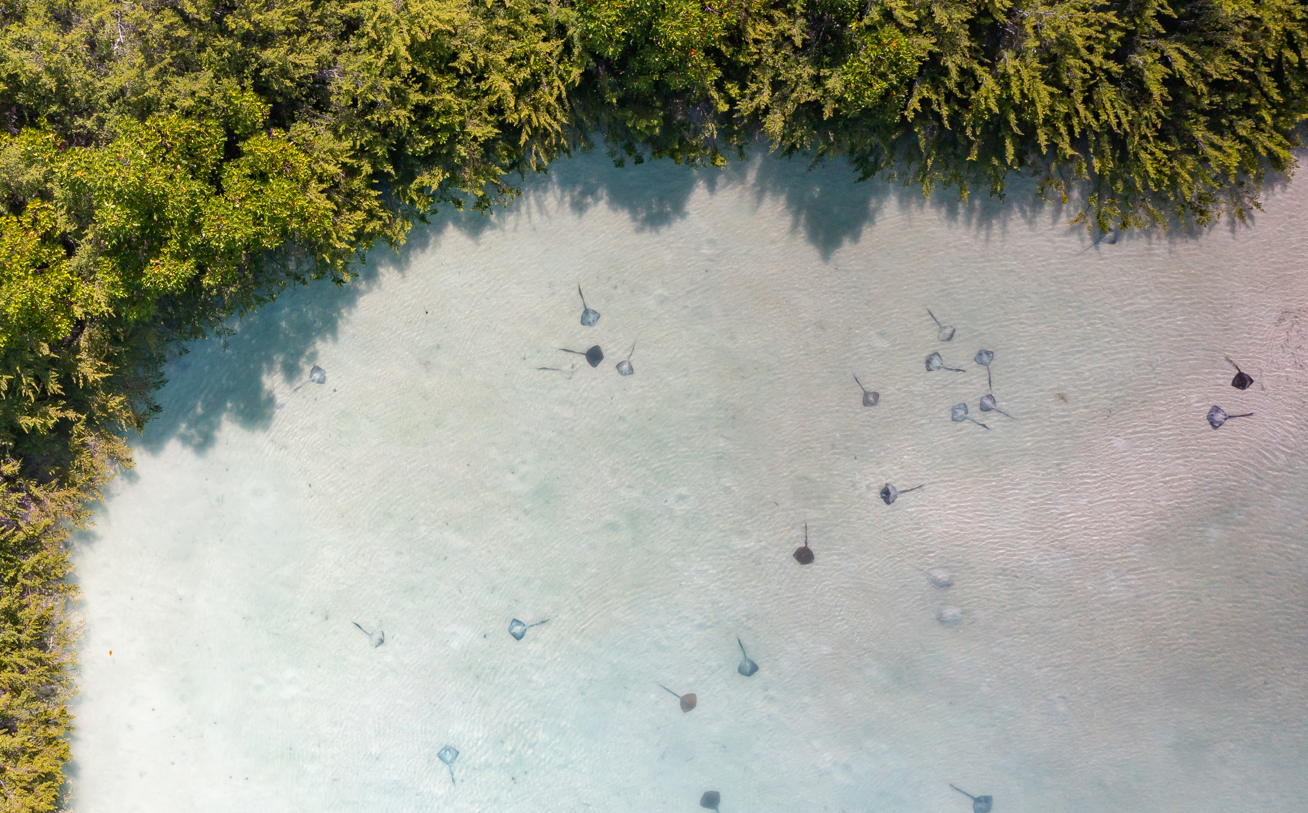
Rays have rarely made it into popular discourse about protection and conservation, but these shark kin are equally vulnerable in unprotected essential habitats. In shallow waters and close to the coast, many sharks and rays come into direct conflict with human-beings and our development footprint - but coastal flats, mangroves and estuaries are also often critical nursery, mating and feeding sites that need special management. Photo by Dillys Pouponeau | © Save Our Seas Foundation
The ISRAs are not legal designations; that is, they don’t represent formal protection in the way that marine protected areas do. Rather, they highlight areas of critical importance that can either become formally delineated as marine protected areas or inform other management measures in the region. What the ISRAs do is provide crucial shark information in a central repository to help inform the description of the spatial planning process. It’s a new departure for many nations, where sharks have seldom (if ever) been used as the species that a marine protected area is designed for or around.
With growing evidence that marine protected areas do work for some shark and ray species, and that other collaborative management measures are needed for migratory or aggregating species or those with seasonal patterns, the time is right for an eAtlas that ensures sharks are firmly on the radar for protection and management in the Western Indian Ocean.
For the Seychelles Inner Islands ISRA specifically, there is existing overlap with other descriptions of the area’s importance to biodiversity (the full complement of life) more generally: the ISRA overlaps with 13 marine protected areas, 12 key biodiversity areas and the Mahé, Alphonse and Amirantes Plateau Ecologically or Biologically Significant Marine Area (EBSA). These key biodiversity areas and EBSAs are delineated in recognition of the life that the diversity of habitats here supports. From sea-grass beds to mangroves and coral reefs, the shallow waters (the Seychelles Inner Islands ISRA only extends to a depth of 50 metres, or 164 feet) are filled with a wondrous array of marine species. And now you can visit the eAtlas online and zoom into the ISRA’s fact sheet to see the array of sharks that helped to inform this delineation: grey reef, blacktip, scalloped and giant hammerhead, spot-tail, snaggletooth and whitetip reef sharks, and the ocellated eagle ray.
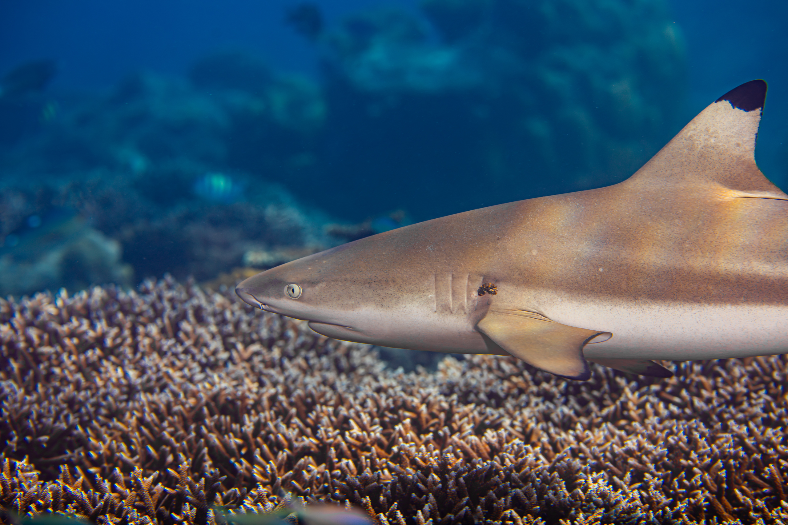
Scientists have shown that coral reef shark species are in decline across the planet, and more recent research suggests that delineating MPAs for sharks can in fact work to protect them, especially where their ranges are restricted, they are endemic (found nowhere else) or they are strongly territorial or associated with preferred sites. The ISRAs are not formal protection measures, but they highlight where policymakers can get the best bang for their conservation buck in their MPA expansion plans. Photo by Dillys Pouponeau | © Save Our Seas Foundation
The question remains: if there are existing processes like key biodiversity areas and EBSAs, and there are already marine protected areas in existence, what value do the ISRAs add to informing conservation strategy in the region? Why zoom in to sharks specifically? The Seychelles Inner Islands ISRA falls within Zone 3 of the Seychelles Marine Spatial Plan and therefore has no strict protected status. The Seychelles Marine Spatial Plan is an initiative that zones Seychelles’ national waters for marine protected areas and sustainable and multiple uses. Zone 3 is a multiple-use zone, which permits certain economic and cultural activities that are in line with long-term sustainability. ‘This, in part, reflects the fact that elasmobranchs were not factored into the initial layering of the marine spatial planning map or the related Marxan process,’ explains John. (Marine spatial planning is the term used to describe the process of designing and delineating a marine protected area, based on different layers of information about biodiversity, habitat and threats. Marxan is the software that conservation planners use to model different protection strategies and scenarios.) ‘So new and additional measures beyond the scope of the current marine spatial plan will be required if some of the issues are to be addressed,’ he continues.
As an environmental professional in the Western Indian Ocean, John has written various national strategic policy documents, including: the Seychelles National Biodiversity Strategy and Action Plan (2016–2020), the Seychelles Marine Spatial Planning policy, the Blue Economy Concept paper and the Seychelles National Plan of Action for the Conservation and Management of Sharks (2007–2011 and 2016–2020). Speaking of the integration of ISRAs into existing policies and plans, he adds, ‘The ISRA status of the Inner Islands should strengthen the National Plan of Action considerably. The next one, when it is written, will certainly address and build upon the designation of these ISRAs.’
‘One of the more interesting things about the Western Indian Ocean is the sheer number of ISRAs that were identified,’ says Robert. ‘This highlights the incredible work being done in the region and shows how dedicated research can inform important designations.’ He emphasises the phenomenal feat of coordinating information across the 10 nations that manage the Western Indian Ocean – Comoros, France (Réunion), Kenya, Madagascar, Mauritius, Mozambique, Seychelles, Somalia, South Africa and Tanzania – as well as the many other stakeholders involved in the ISRAs process. ‘As for Seychelles, the variety in the size and geography of the identified ISRAs here highlights the importance of this island nation to all kinds of species at various life stages, using different areas in different ways,’ he explains.

Strong science underpins the ISRAs process. At D'Arros Island and St Joseph Atoll, decades of work on reef manta rays showed that these animals range across the Amirantes Bank in Seychelles, but return reliably to preferred sites. The Amirantes Bank Northern Madagascar ISRA is a particularly good example of how tagging and tracking research helped highlight large scale migration corridors of threatened species. Photo by Dillys Pouponeau | © Save Our Seas Foundation
Robert and his team at the SOSF-DRC are responsible for the long-term research on D’Arros Island and St Joseph Atoll and his experience in the region helps to integrate the local vision with the wider Seychellois (and Western Indian Ocean) priorities. ‘Our different types of research can inform different kinds of ISRAs,’ he explains. ‘Some protect large migration areas and others target more restricted, but highly important, nursery sites. For instance, some of the newly announced ISRAs are vast areas of ocean and form key migration corridors, whereas others, like the D’Arros and St Joseph ISRA, are highly restricted areas that are essential as nursery habitat for young sharks and rays.
‘The Amirantes Bank Northern Madagascar ISRA is a great example of how tagging and tracking research can provide vital insights to help protect the large-scale migration corridors of threatened species. Fishing constitutes the single largest threat to sharks and rays worldwide and many species suffer increased exposure to fisheries during routine migrations. By identifying the pathways that sharks use when moving between core areas, we can inform management more precisely for those areas.’
The release of the ISRAs eAtlas for the Western Indian Ocean showcases the important role that Seychelles’ waters play in the long-term persistence of sharks and rays. Robert’s and John’s insights help us to understand what this will mean for their management and protection, but Sheena adds a different angle. ‘I believe that the work begins now,’ she says. ‘The ISRAs showcase the importance of our vast exclusive economic zone to sharks, but that’s only half the battle. More needs to be done at the grassroots level to illustrate why sharks are important to Seychellois economically and ecologically.’ For a region that is so invested in its reliance on the biodiversity and well-being of the ocean, there is work to be done in ensuring that the connection between conservation and livelihoods, between environmental protection and social justice, is made explicit and understandable. For Sheena, the decades of investment by scientists and conservationists in the valuable ISRAs process will only find traction when the accessibility of the information is translated to participation and buy-in on the ground. ‘Our work is not complete without the involvement and active participation of the people.’